20.12.10

The Nabateans Culture - Archaelogical sites in Middle-East

The Nabateans were an ancient Semitic people of southern Jordan, Canaan and the northern part of Arabia. The Nabateans archaelogical sites are not a single site but a group of sites at Petra, Shivta, Avdat, Bosra  and other places providing a glimpse of the ancient architecture making up for an exciting trip.


Petra
Established sometime around the 6th century BCE as the capital city of the Nabateans, it is a symbol of Jordan as well as its most visited tourism attraction. Petra was chosen by the BBC as one of "the 40 places you have to see before you die". Excavations have demonstrated that it was the ability of the Nabataeans to control the water supply that led to the rise of the desert city, creating an artificial Oasis. The area is visited by flash floods and archaeological evidence demonstrates the Nabataeans controlled these floods by the use of dams, cisterns and water conduits. These innovations stored water for prolonged periods of drought, and enabled the city to prosper from its sale. Some pointers to christanity are also available such as the 'Urn Tomb.


The Amphitheatre at Petra is also witness to what the culture had on offer then. Other wonders to see in Petra are El Deir (The Monastery) , The Hadrien Gate and the Sandstone caves. The Al Khazneh derives from one legend that bandits or pirates hid their loot in a stone urn high on the second level. Significant damage from bullets can be seen on the urn. Local lore attributes this to Bedouins, who are said to have shot at the urn in hopes of breaking it open and spilling out the "treasure" within (the decorative urn, however, is solid sandstone). Another is that it functioned as a treasury of the Egyptian Pharaoh of the time of Moses (Khaznet Far'oun


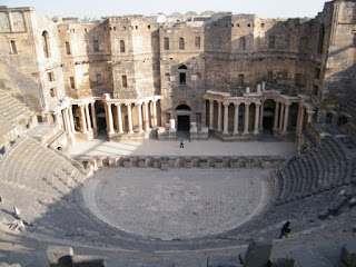
Bosra-  is an ancient city administratively belonging to the Daraa Governorate in southern Syria. It is a major archaeological site and has been declared a UNESCO World heritage site. Today, Bosra is a major archaelogical site, containing ruins from Roman, Byazntine, and Muslim times, its main feature being the well preserved Roman theatre. Every year there is a national music festival hosted in the main theater.


Mada in saleh -  The site constitutes the kingdom's southernmost and largest settlement after Petra, its capital. In 2008, for its well-preserved remains from late antiquity, especially the 131 rock-cut monumental tombs, with their elaborately ornamented façades, of the Nabatean kingdom, UNESCO proclaimed Mada'in Saleh as a site of patrimony, becoming Saudi Arabia's first World Heritage Site. According to the Islamic text, Allah punished the Thamudis for their persistent practice of idol worship and for conspiring to kill the Propeht whom he had sent, the non-believers being struck by an earthquake and lightning blasts. Thus, the site has earned a superstitious reputation down to contemporary times as a cursed place.


Places to See

Shivta -  Another Archaelogical site from the Nabataen times, It is not under the army control. The Shivta site contains three Byzantine churches, 2 wine-press, residential areas and administrative buildings. After the Arab conquest in the 7th Century CE, Shivta began to decline in population. It was finally abandoned in the 8th or 9th Century CE.

Avdat- A smaller site with ruins relating to the Nabatean culture.

Wadi Rum- A major site of Nabatean Petroglyphs.

Directions, Accomodation and Duration

By Road: JETT buses connect to Amman and Aqaba via the Desert Highway. Other buses also come from Eilat. Tours to Petra from Taba, Sinai, Wadi Rum, Amman and Sharm el Sheikh are also gaining popularity with charter tourism.

Nearest airports are at Tel Aviv, Ammam and Eilat.

Accomodation: Guesthouses are available in Wadi Rum. Also various cheap motels and luxury resorts have come up around Petra.

Duration: The total trip including all the sites will require 7-10 days. The sites include various contries including Syria, Jordan and Iran so be prepared to arrange for prior visas where necessary.

* - http://en.wikipedia.org/wiki/Nabateans

12.12.10

Plitvice Lakes National Park - Croatia

We humans have always attached colours with happiness. The rainbow is the perfect example of it. Plitvice Lakes located in Croatia is another fine example with its ever colour changing lakes. Plitvice lakes National Park  is a national park in Croatia in the Plitvice Lakes Municipality, in the mountaineous region of Lika. The lakes are renowned for their distinctive colours, ranging from azure to green, grey or blue. The colors change constantly depending on the quantity of minerals or organisms in the water and the angle of sunlight.


The lakes are separated by natural dams of travertine, which is deposited by the action of moss, algae, and bacteria. The encrusted plants and bacteria accumulate on top of each other, forming travertine barriers which grow at the rate of about 1 cm per year. The sixteen lakes are separated into an upper and lower cluster formed by runoff from the mountains, descending from an altitude of 636 to 503 m (2,087 to 1,650 ft) over a distance of some eight km, aligned in a south-north direction. The lakes collectively cover an area of about two km², with the water exiting from the lowest lake to form the Korana river.


The lakes are renowned for their distinctive colours, ranging from azure to green, grey or blue. The colors change constantly depending on the quantity of minerals or organisms in the water and the angle of sunlight.

Under the travertine waterfalls Cratoneuron moss sometimes grows, the moss gets encrusted with travertine and fresh moss grows further out, first a crag is formed but later a cave roof forms under the crag. If the water continues flowing the cave becomes progressively bigger. Limestone caves are present as well. Rare fauna such as the European Brown bear, Wolf, Eagle, Owl, lynx, wild cat and capercaillie can be found there, along with many more common species. At least 126 species of birds have been recorded there, of which 70 have been recorded as breeding there.


Croatia's first National park established in 1949 covers 296.85 km2 of breathtaking natural splendor.  About eight km of pathways and wooden walking trails around lakes are accessible to visitors. Hiking is a common activity with organized programs for park visitors, other possible activities include: electric boat and train ride, cycling, skiing and rowing. The park ski area is the perfect outdoor and ideal for ski vacation destination

History of the Splitvice Lakes National Park
In March 1991 the place became the scene of the Plitvice Lakes incident - the first armed confrontation of the Croatian War of Independance that resulted in fatalities. The park was held by local Serb rebels backed by Slobodan Milosevic and the JNA as part of the self-proclaimed Republic of Serbian Krajina during the conflict and suffered some damage in the process, with hotels and other facilities being used as barracks. At auto-camp Grabovac there were civilian deaths (three children) from a Yugoslav Army shell in September 1991. During the period under the control of Serb forces loyal to Belgrade, Croats were ethnically cleansed from the region systemically. The region was retaken by the Croatian Army in August 1995 during Operation Storm, which ended the Croatian war.

Places to visit
 The nearby city of Split is only 125kms apart and boasts of a distinct architecture. Diocletian's palace is the single most important monument in the city and definitely not to be missed.


Directions, Accomodation and duration
The trip to Plitvice Lakes National Park will take a day. Add two more days to roam and explore the beautiful city of Split, Croatia.  All hotels are situated at Velika Poljana, central tourist zone of the Park, except campsite Korana which is located 6km prior to Entrance 1. Closest airport is Zagreb airport - about 140km away, while railway connections are in Karlovac (90km away) or again Zagreb (140km away). Approximately 30 buses pass to/from Zagreb/South Croatia daily.

*- http://en.wikipedia.org/wiki/Plitvice_Lakes_National_Park
*- http://www.np-plitvicka-jezera.hr/en/index.php

5.12.10

Blue Grotto - Capri

The Blue Grotto is a marvellous sea cave located on the islnad of Capri in Italy. Just like all things Italian beginning from food to cars and girls, The Blue Grotto has its own charm. Because there is no headroom, visitors must lie on their backs in the bottom of the rowboats as they clear the entranceway. Once inside, the grotto is quite roomy and it is possible to sit upright, until conveyed back out through the same tiny hole. When the weather is fine, waterborne traffic jams frequently occur outside the grotto, as the rowboats jostle for positions to enter the cave in single file

Sunlight, passing through an underwater cavity and shining through the seawater, creates a blue reflection that illuminates the cavern. the light comes from two sources. One is a small hole in the cave wall, precisely at the waterline, that is perhaps a meter and half in diameter. This hole is barely large enough to admit a tiny rowboat, and is used as the entranceway. In photographs taken from within the cave, the above-water half of this hole appears as a spot of brilliant white light. The second source of light is a second hole, with a surface area about ten times as large as the first, which lies directly below the entranceway, separated from it by a bar of rock between one and two meters thick. Much less light, per square meter, is able to enter through the lower opening, but its large size ensures that it is, in practice, the primary source of light.


History of The Blue Grotto

 Due to colonization of other continents the best kept history is found in Europe. The grotto was known by the Romans, as proved by the antique statues which were found in the Grotto. This discovery, the remains of an ancient landing place and the work on an underground tunnel, create an image of a natural cavern adorned by statues. The grotto was known to the locals under the name of Gradola, after the nearby landing place of Gradola, but it was avoided because it was said to be inhabited by witches and monsters.

The Island of Capri

Capri is an Italian island in the Tyrrhen Sea off the Sorrentine Peninsula, on the south side of the Gulf of Naples, in the Campania region of Southern Italy. It has been a resort since the time of the Roman Republic.
Features of the island are the Marina Piccola (the little harbour), the Belvedere of Tragara, which is a high panoramic promenade lined with villas, the limestone crags called sea stacks that project above the sea (the Faraglioni), Anacapri, the Blue Grotto, and the ruins of the Imperial Roman villas.


Places to visit

1. Anacapri: The most untouched part of the island in its natural splendour along with churches and museums.
2. Faraglioni: It is the greatest feature of the island and is formed by four reefs floating in the blue sea. The first is called Stella or Star and it is 109 meters high; the second is called Mezzo or Middle and it is 81 meters high, the third faraglione is 104 meters high and hosts a blue lizard, a rare animal species; finally the fourth faraglione lies by itself and it is called the Monacone.
3. Gardens of Augustus: The gardens were built among the ruins of ancient Roman Empire. Krupp gave the gardens to the town of Capri and in the garden lies a statue of Lenin by the sculptor Manzu.
4. The White Grotto: The White Grotto and the cave are two wonderful cavities both directly accessible from the sea through a series of very steep steps built in 1901 by two Englishmen.
5. Beaches of Capri: The beaches are soaked in a fantastic atmosphere rich of suggestive natural beauty like a postcard full of coloured building all around with its massive rocks which doubtless remain the paradise described in the novels of the most popular artists and writers who inhabited the Island over the course of centuries.
6. Roman Remains: There are lots of Roman remains on the islands that make it a historical marvel. These include mount Villa Jovis-Mount Tiberio and The Charterhouse of St. Giacomo.

Directions

Capodichino International Airport links Italy’s Campania region with the other national and international airports. Capri is a tiny island just off the coast of the historic southern Italian city of Naples. Planes land at Naples Capodichino Airport and from here passengers can reach the ports either by taxi or bus. Trains arrive at Naples' Stazione Centrale, Piazza Garibaldi and Mergellina railway stations.

Those traveling by car will need to follow signs to the city's ports. It's worth remembering that for almost seven months of the year, the Island of Capri is closed to non-resident traffic and drivers are best advised to park their vehicles in one of the security surveilled car parks in the vicinity of the ports.

Boats heading to the Island of Capri from Naples depart from Molo Beverello and Calata Porta di Massa.

Hydrofoils depart from Molo Beverello, situated in Piazza Municipio and close to the central Via Toledo.

Duration and Accomodation

The trip around Capri can be completed in 2-3 days but many tourists take a leisurely time to enjoy the islands beauty and freshness for a longer period. A lot of luxurious and innovative resorts are situated on the islands itself providing accomodation.

Beauty Level 9/10: The most beautiful of all tourist sports with its clean and transperant water. A definite addition to the list of things to see in and around Italy.

Adventure level 8/10: The endlessness of the sea with vertical cliffs, the clean beaches and the favourable weather provide a lot to explore.

*- http://en.wikipedia.org/wiki/Blue_Grotto_(Capri)
*- http://en.wikipedia.org/wiki/Capri
*- http://www.capitanoago.com/capri_attractions.php
*- http://www.capri.net/

28.11.10

London Bridge is falling down-Port Campell National Park.

London Bridge is falling down,
Falling down, falling down.
London Bridge is falling down,
My fair lady.
 
Time to go back to school if these lines do not remind you of your kindergarten days. If I ask you to guess the monument I am talking about, you will probably say the London Bridge, England. You are close to the answer. Some thousands of kilometers close. What I am mentioning here is the natural bridge named the London bridge located in Victoria Australia.
 

 London bridge is a major natural arch created by water erosion. Recently renamed as the London arch after the breaking down of a major portion, it is one of the major attraction at Port Campbell National park.


The arch closest to the shoreline collapsed unexpectedly on 15 January 1990. An incident that also plagued the PercĂ© Rock, Canada. As part of the Port campbell National part London Bridge holds the main attraction along with the twelve apostles. The Twelve Apostles is a collection of limestone stacks off the shore of the Port Campbell National Park, by the Great Ocean Road in Victoria, Australia. Their proximity to one another has made the site a popular tourist attraction. The stacks are susceptible to further erosion from the waves. On 3 July 2005, a 50 metre tall stack collapsed similar to the fate of the London Arch.


The next visitor attraction at the Port Campbell National Park along the Great Ocean Road is the Loch Ard Gorge. you park across the road near a tourist centre and then trudge with hundreds of others through a tunnel under the Great Ocean Road to the wooden walkways and viewing platforms. The Loch Ard Gorge provides and excellent private beach atmostphere and is worth a visit. The gorge ends in two coves divided by a dramatic rocky outcrop which share one beach. From here the long gorge heads out to the open sea. The shipwrech site can be visited too.

There is a blowhole at the Loch Ard Gorge. The blowhole is connected to the sea by a long but narrow tunnel. When high seas enter in, the waves compress air and enter the tavern with a loud roar. The tunnel extends to about 100 metres and is increasing based on corrosion.


Next on the list will be the Grotto. The Grotto is a sinkhole geological formation and tourist attraction, found on the Great Ocean Road outside Port Campbell in Victoria, Australia. Wooden steps wind down the cliff face to the bottom, providing visibility of the sea beyond a pool at low tide. The Grotto looks like there is nothing there until you get down to sea level and look through an arch out to part of the ocean. Beyond the arch lies a still pool and then the open sea


The whole trip is best taken along The Great Ocean Road which is a 243 kms long stretch of road along the South Eastern Coast of Australia.  The road begins at Torquay and travels 243 kilometres westward to finish at Allansford near Warnambool the largest city along the road.

Other attractions

Gibson steps- Steps to a wonderful beach at the Port campbell National Park at the beginning of The Great Ocean Road.

razorback- a stone range sticking out in the sea.

Snorkelling and scuba diving tours are also available in the area. Surfing is possible at Bell's beach along the Great Ocean Beach where various surfing competitions are held.

Directions and Accomodation and days required

A total of three to four days will be required depending on how much time you would like to spend at the beach.

The 250 km drive from Melbourne via the Princes Highway takes about three hours. A more scenic but longer and winding route, the famous Great Ocean Road takes about five hours. Organised bus tours are available. Vic Roads Touring Guide Map 100 gives additional detail.


various motels are available at port cities along the way.

Beaty level 6/10 - The scenic drive and the natural rock formations make for an exciting adventure for your eyes.

Excitement Level 8/10 - The landmass provides for some excellent hiking opportunities along with snorkelling and scuba diving activities. A great way to spend the summer bathing in the sea. A great added bonus is the drive on the Great Ocean Road.

References
*- http://en.wikipedia.org/wiki/London_Arch
*- http://en.wikipedia.org/wiki/The_Twelve_Apostles,_Victoria
*- http://en.wikipedia.org/wiki/The_Grotto,_Victoria
*- http://www.parkweb.vic.gov.au/1park_display.cfm?park=175

21.11.10

Oldest hotel in the world.

When was the last time you saw a structure that was built in 1300 years ago? Add to that the last time you got to stay in such a place. Hoshi Ryokan( Ryokan is a traditional Japanese inn) in Ishikawa, Japan which was founded in 718AD is the oldest inn in the world. This fact has also been acknoldged by the Guinness Book of world Record. Also appreciative is the fact that Hoshi Ryokan is the oldest continuous operating company in the world with the same owners running it for forty six generations.


The hotel came into operations when an inn was built near a hot-water spring said to have miraculous healing properties. The waters are still celebrated for their recuperative effects. The Ryokan has evolved through the centuries. A new guest, on arrival, is garbed in a "Yukata", the japanese traditionnal cotton kimono. Located in Japan's Ishikawa Prefecture, the hotel began as a spa on an underground hot spring which was built by the Hoshi family because, according to legend, the god of Mount Hakusan ordered it.


The story of the Hoshi Ryokan began in 717, when Taicho Daishi, one of the greatest Buddhism teachers in the history of Japan, climbed Mount Hakusan to perform his training exercises. One night, while he was asleep, the spirit of the mountain appeared in his sleep and spoke to him of a miraculous underground spring, located in Awazu village, 20-24 kilometers from the base of the mountain. He was instructed to travel to this wondrous place and, with the help of the villagers, unearth the hot spring that would cure the people of all their illnesses. So Taicho and his disciple , Garyo Hoshi went there. With the help of villagers they managed to locate the spring. Taicho told the sick to bathe and soon their health becomes better. Taicho ordered his disciple, Garyo Hoshi, to build a spa on the site. Since then, the Hoshi family members has been running the Hoshi Ryokan for 46 generations. Zengoro Hoshi is the current patriarch of the family business. With 100 rooms, Hoshi Ryokan can accommodate up to 450 guest.


Hoshi Ryokan buildings are named after each season in Japan.

Shinshun no Yakata (Early spring building).
Haru no Yakata (Spring building)
Natsu no Yakata (Summer building)
Aki no Yakata (Autumn building).

One night in Hoshi Ryokan costs around 350 USD per person with breakfast and dinner included. They also offer activities like tea ceremony or guided tours around the area. The best thing they offer are the hot springs, known in Japan as onsen.

Directions to reach the hotel.

By express train, four hours and 30 minutes from Tokyo, 2 hours and 30 minutes from Osaka, and 2 hours and 30 minutes from Nagoya.
By plane, one hour from Tokyo; 1 hour and 30 minutes from Sapporo, 1 hour and 15 minutes from Fukuoka, and 1 hour from Sendai.

By Road, Hokuriku Expressway, Katayamazu Interchange; Komatsu Interchange.


Places to visit nearby-
The most popular destination in Ishikawa is Kanazawa. Tourists can get to Ishikawa by plane via Komatsu.

Shibayama Lagoon
Mount Haku
Kaga hot-springs district
Kenroku-en
Higashi-chaya district in Kanazawa
21st Century Museum of Contemporary Art, Kanazawa
Chirihama Driveway
Wajima Morning Market
1000 Rice Fields


Accomodation- At the place itself.
Beauty level- 8/10 The place boasts of seren historic architecture even though it has been renovated from time and again.

Excitement level- There is not much to see nearby and unless its the springs you are interested in, there is not much adventure.
*
- http://www.ho-shi.co.jp/jiten/Houshi_E/index.htm
- http://www.wikipedia.com/
- http://www.ho-shi.co.jp/jiten/Houshi_E/index.htm
- http://something-interesting4u.blogspot.com/2009/10/hoshi-ryokan-oldest-hotel-in-world.html

Twitter Delicious Facebook Digg Stumbleupon Favorites More